

Hiking The Oregon Coast Trail, Day 10 Part 1: The Ocean Claims My iPod
I currently live in the Central Valley of California, and every time I return home from an adventure in the Sierras or from a peaceful few days at the ocean, there’s a certain moment on the highway when I notice the inescapable, overwhelming stench of cattle farms. It smells like disappointment – an olfactory-driven reminder that I’m no longer out in nature. That I’ve traded forest air or sea mist for concrete and congestion.
Well, Tillamook smells pungently of cows this morning, and I don’t necessarily hate it. Which surprises the hell out of me. Then again, it’s a small town wrapped in the quiet folds of farmland and forest, yet only a few miles from the ocean. That smell feels like it belongs here.
I realize it’s not the smell I’ve resented all these years. It’s what the smell signified.
Here in Tillamook, it just smells like morning.
As I’m prepping my pack, I feel pangs of excitement and anticipation. At some point today, I’m going to hit 100 miles hiked on the OCT! For a brief few minutes, I try estimating exactly where it will happen on the route to tonight’s camp at Cape Lookout State Park. But I’m learning that each day out here is dynamic. Instead of fretting about the milestone, I’ll focus on the present.
And right now, it’s time to pick up the trail at Cape Meares Beach.
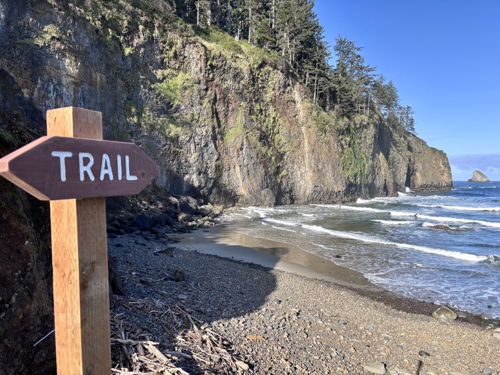
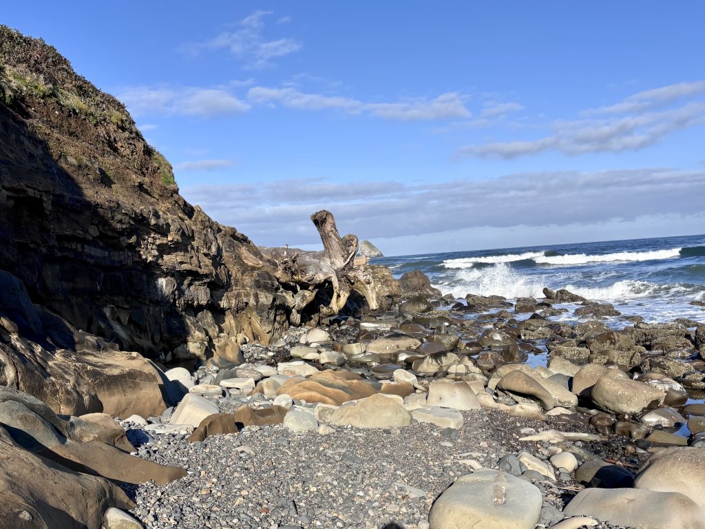
Within half a mile of walking, I reach a short rock ledge slowly being consumed by the tide. Its base is completely surrounded by boulders. Some are smooth, some look jagged, but the combination of an incoming tide and uneven footing makes simply walking around it a potentially dangerous course of action.
Am I also freaked out by the horror stories of sneaker waves, and my own close call camping on the beach near Hug Point? I absolutely am.
There’s a point just before the rock ledge rises sharply that is nine or ten feet high, so I decide to climb up and over. As I peek over the top, I’m relieved to see a small open beach area just before Cape Meares itself, so I unclip my pack from around my waist and gently toss it over. Well, as gently as you can toss a 40-pound backpack.
As I’m swinging it around, one of the straps gets snagged on a driftwood branch and I take a few seconds to wrestle it free. Within a few minutes I’m up and over.
As I shoulder my pack and reach for some water in the right-side pocket, I realize the SmartWater bottle that should be there is missing. And after my hand comes back empty-handed, it brushes against my waist strap where my beloved iPod is normally clipped.
Gone!

In a panic, I scramble back over and spot the bottle floating in the water between two boulders. I lift it out of the water to see it leaking profusely, punctured in multiple places. This particular brand of water bottle can stand up to a lot of abuse, which is why it’s a favorite among backpackers, but it couldn’t survive whatever it landed on.
Because I’m a music junkie, I’ll plainly admit I’m less bothered by losing half of my water as I am losing my iPod. Besides, I have my Sawyer Squeeze so if push comes to shove, I can filter any freshwater source I come across.
It’s not just any iPod, though. It’s a 5th Generation iPod Classic modded with a brand new, double-capacity battery, a striking blue case, and a massive 512GB flash drive that fits my entire music collection.
And it’s nowhere to be found.

I spend several panicky minutes hopping among the boulders and scanning the surface of the water, even as my heart sinks in the realization that the tide has probably carried it out.
My guess is that when I swung my pack off and it got snagged on the branch, the wind and surf masked the sound of my water bottle falling away and my iPod getting unclipped and quietly splashing into the water.
The Pacific Ocean has likely swallowed it up, and I feel devastated. I know it’s replaceable, but it doesn’t stop me from being flushed with anger at myself for not being more careful.
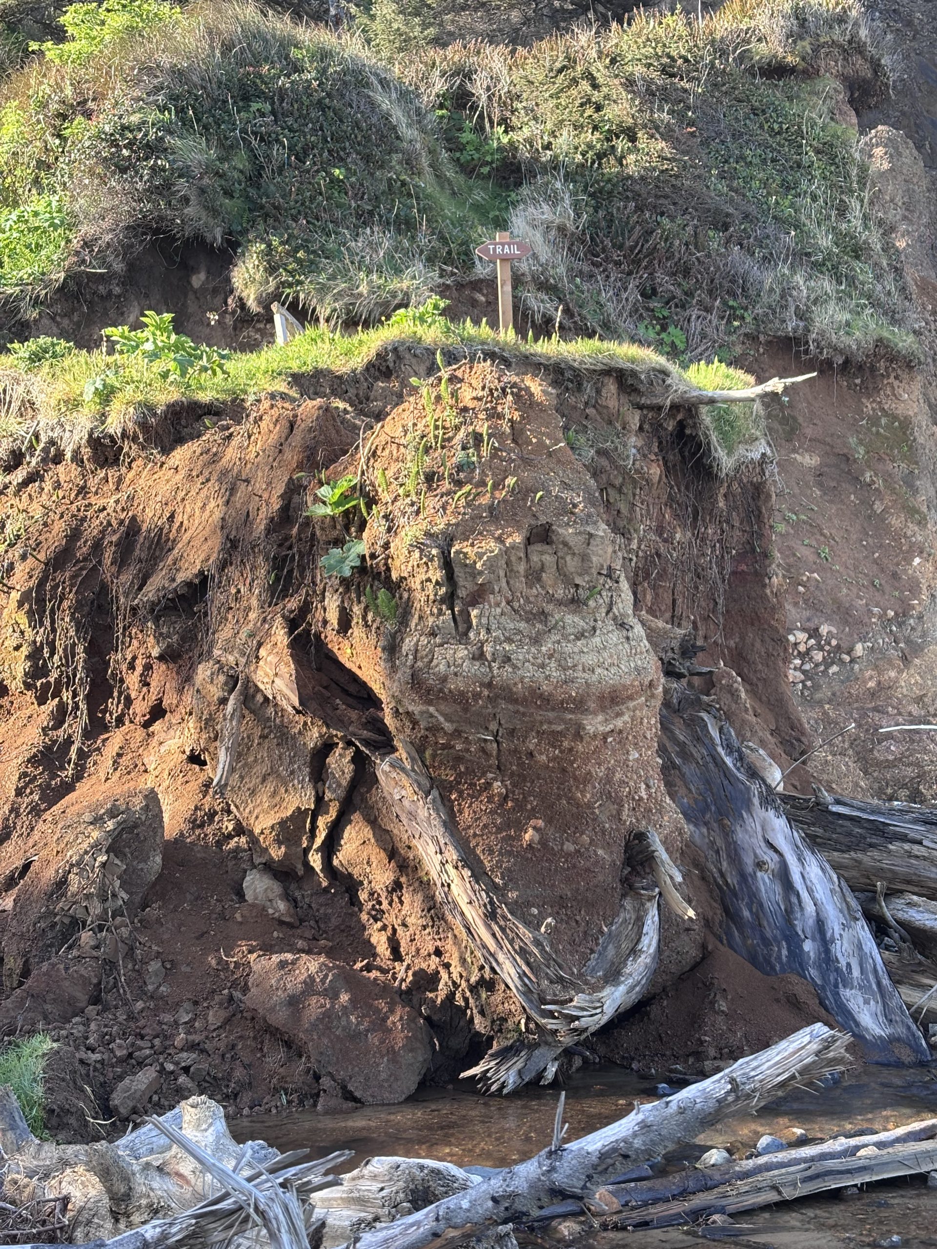
The Cape Meares Scenic Trail is a wreck. My first clue happens immediately with the dramatically eroded bluff leading up from the beach to the trailhead. A fractured column of earth sits exposed, jutting sharply downward, seemingly propped up by a network of stringy roots and massive driftwood logs. Hilariously, the trail marker up top looks like it’s inches from the edge.
I scramble my way up the steep slope, slipping and sliding on the slick earth. This is going to be a long day…
Less than a mile into the admittedly scenic trail (but aren’t they all on this wondrous Oregon coast?), a massive landslide blocks the path. My best guess is the barrier is at least 14 feet high, littered with whole uprooted trees and various exposed debris poking out of the muddy wall. Ferns and young saplings have started sprouting on the surface of the wreckage, so this must have happened during a winter storm.
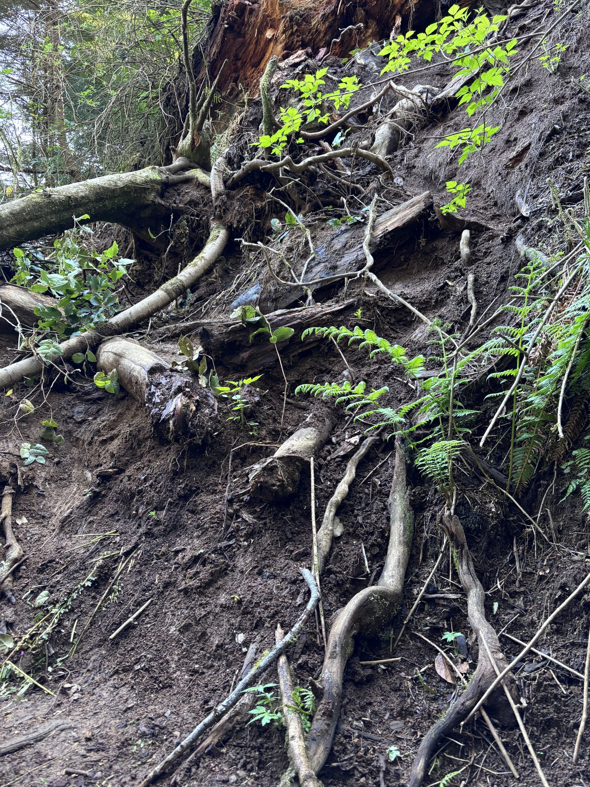
For the third time this morning, I summon all my strength to scramble over an obstacle that would be ten times easier without this heavy backpack weighing me down. I suddenly gain immense respect for people who go bouldering and climbing. And I realize that despite putting in nearly 100 miles on this adventure, I’m not nearly as fit or conditioned as I should be.
After this, it feels like I’m climbing over treefall every other switchback. This portion of the trail has been decimated, and I’m utterly baffled by the lack of any closure signs.
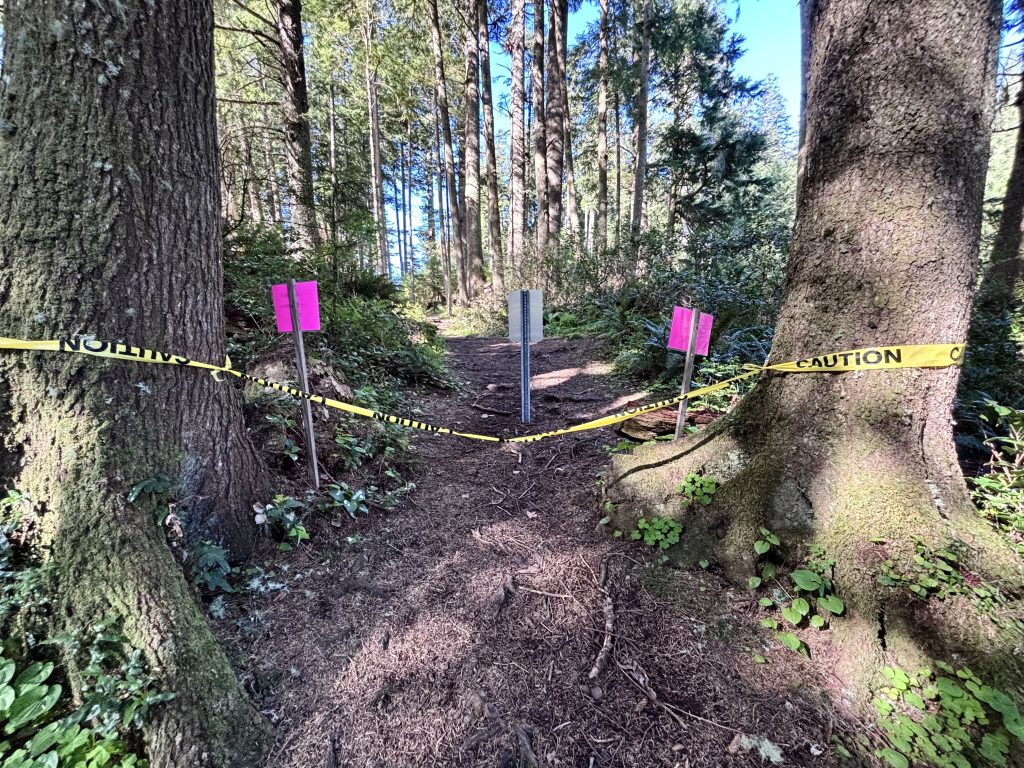
That is, until I come to a level clearing and see yellow “Caution” tape stretched out between two large trees that bookend the trail, and the backside of two bright pink warning signs. I high-step over the tape blocking the path, and read the signage: “Trail closed due to severe storm damage.”
Yeah, no kidding!
Still, it’s difficult to stay angry for more than a minute. During the past two weeks, I’ve seen how dynamic the hiking experience can be on the Oregon coast, and I have serious respect for the trail keepers who must constantly be challenged by how much damage the weather can incur. They must have quite a backlog of repairs and maintenance.
Just past the warning signs, there’s a small parking lot for this trailhead and a road that leads west to the Cape Meares lighthouse. A road I’m grateful for at the moment. Even! Solid! Smooth! Stable! The small detour isn’t technically part of the OCT, but it’ll almost certainly offer a stunning viewpoint and an ideal place to eat some lunch, catch my breath, and summon up some energy for the rest of today’s hike.
Coming up in Part 2: the 100-mile milestone, a shocking conversation at the lighthouse, and generosity at Oceanside’s Current Cafe.
Member discussion